Day 1 - Shitkadi, Somanarg to Nichnai basecamp
Altitude: 9000ft to 11500ft
Total Distance: 15kms
Total Time: 07h22m
It was a bright and sunny day with prediction of rain as the day progressed. We got pumped up after morning warmup exercises and started ascending right away. The pleasant walk become challening as nature had some other plans for us. it started raining cats and dogs followed by hails and strong cold winds which forced us to take shelter under trees. After waiting for some time we resumed ascending towards a point called table top. This was placed at nearly half the distance of total desired distance on day 1.
Reaching to this point seemed easy as we had already faced bigger challenges of rains and hails. We had maggie and kahwa which was a booster in those conditions. Post the much needed break we started ascending again towards Nichnai base camp. This was a tough climb of 30 minutes followed by a not so easy trail as the rains made the trails extremely slippery. Also rains reappeared.
We were given packed lunch which we decided to eat anyways irrespective of the continuous rains. Eating rice with raindrops in it was kind of gross but it was needed to infuse some calories in our bodies. After nearly 6h30m of walk I could see the campsite but it wasn't ours. Our campsite was far away(nearly 1h+ time) from TTH and indiahikes. At that point of time, we just wanted to reach out campsite and this additional time kept on lingering on our mind.
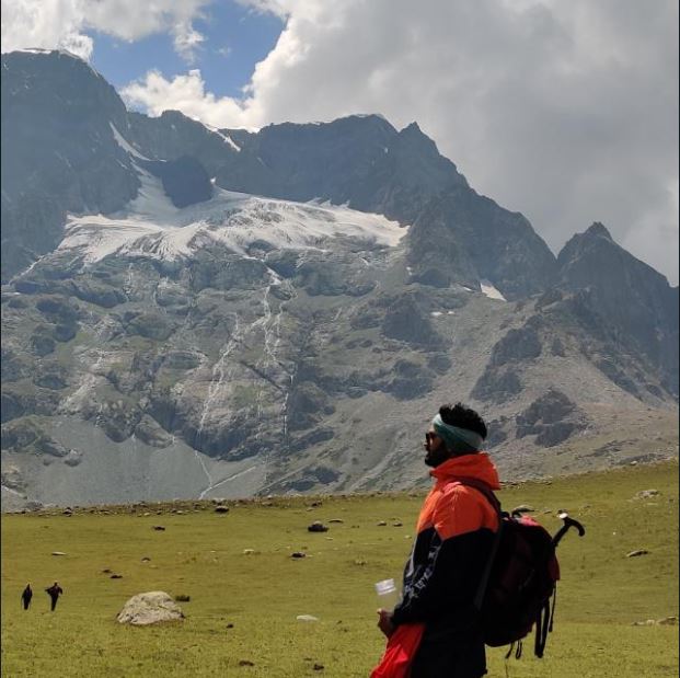
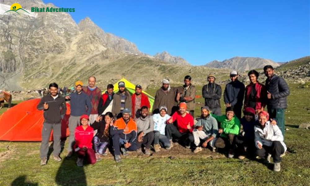
Eventually we reached the campsite around 4:22PM which according to our trek leader was slow. But we ignored him gracefully as reaching to campsite without any injuries elated us. Though we were having pains in shoulders, back and legs but it was totally worth it. We clicked picturesque views of fresh snow coated mountains and went to dining tent for soup and dinner later on. This concluded day1.
Day2
=====================================
Nichnai Basecamp to Vishansar Basecamp via Nichnai pass
Altitude: 11500ft to 13600ft to 12000ft
Total Distance: 13.4km
Total Time: 07h05m
We were given timings of 6 (wake up), 7(breakfast), 8(trek start) at the time of briefing last night. It was a sunny day which was a relief as no one wanted to face rains again. We left from tents at 8:30 and headed to 1st pass of KGL trek:- Nichnai pass (13600ft).
We began by walking on a river where boulders were present and river water was almost dried so it became an easy patch to cross. The trail ascended after crossing the river and we could see the top of the ridge line. Nichnai pass was slightly far from this point. Reaching to the ridgeline was tiring so we took a break and had water/refreshments. Few individuals got busy in capturing the views in their camera. Paras and Tejal were on high demands due to their photography skills. There was tiny lake on the left side which somewhat resembled with the map of our country.
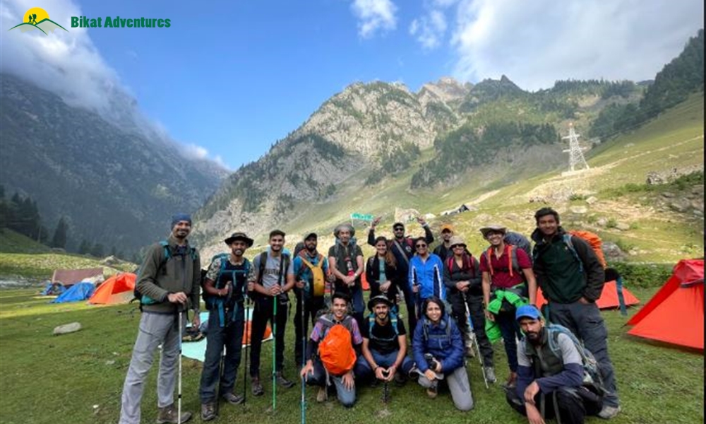
Post the break we resumed the trek, some walked on the boulders so that the mules could take the usual trail. After a tough climb, we reached at Nichnai pass and had hot bewerages - all thanks to tea/maggie shop (this was the last maggie point we would see during the trek, except for the last day). We decided to wait for whole group to arrive. khyati offered me sweet snacks which restored the energy.
There was a steep descent post this break. We got accompanied by snow capped mountains on our left, barren mountains on our right and colourful flowers all around. Some trekkers were returning back as it rained heavily for the last 2 days and it probably ruined their trek to Gaddar pass (which is our day 3). But we embraced the optimistizm of rains not ruining our day 3 ascend.
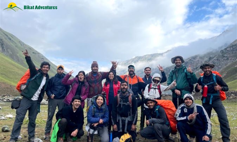
We kept on walking for next hour and reached to a riverside where few members of our group were waiting for us. There we had paratha and potato sabzi for lunch.
Sun was showering sunshine all the way through. we ran into flocks of sheep, grazing on the meadows. Few of us got busy with photography again as this place was mesmerizing. We were told we would reach campsite in another 2h but I didn't believe them. Their measurement of the distance beats my mind. We continued walking and I could see our campsite that required us to cross a river stream. We reached the campsite at 3:30 PM, collected our ruksack, sleeping bags and went for stretching. Post tea, we walked 5-10 minutes from our campsite and finally had glimpses of Vishansar lake and what a pristine sight this was. Clouds over the mountains and its reflection on the blue color lake. We couldn't spend more time on the lake side as winds became too cold so we decided to return to the campsite. Weather wasn't looking promising as nature had some other plans for us that night, threatening our Day 3 ascend to Gadsar paas.
Day 3
==============================
Vishansar Lake to Gadsar pass to Gadsar Lake
Altitude: 12,000 ft to 13,800 ft to 12,500 ft
Trek Distance: 17.1km, Time: 8h17m
==============================
Weather forecast was rainy and hence there was a 50% chance that we would not advance and utilize our rest day. We were asked to wake up by 5 AM and then based on the weather conditions the fate of the trek would be decided.
It rained overnight hence at 6:00AM our trek leaders told us that we would wait till 8:30 and proceed only if weather permitted. Reason being simple-the mountain where Gadsar pass lies was extremely risky for mules after rainfalls. If mules couldn't go so couldn't food hence no point continuing the trek. Fortunately, the sun appeared and we started the trek as early as 7:20AM
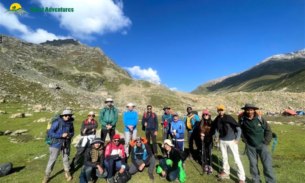
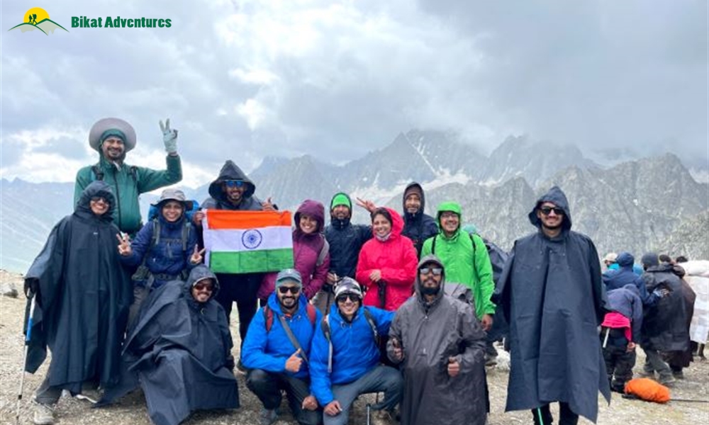
Kishansar Lake was on the left immediately after few minutes of trekking, which is deeper than Vishansar Lake. As the sun was playing hide and seek with clouds, people started clicking picutures. Few moments later we started ascending a very steep mountain - the toughest climb of the trek. With multiple breaks we reached to Gadsar pass (in well under 3h) and it welcomed us with light showers of snow. We felt no less than reaching to a summit. We clicked group photos, wished Nachi as it was his bday. Though it was cloudy we could still see the blue coloured lakes (vishansar and Kishansar) from the pass.
Next phase was descending, the trail was rocky, muddy, slippery and very risky. We could see the mules crossing us - a sigh of relief that the trek would finish.
After few hours of cautious walk we found the trail to be levelled. We halted for lunch after few more hours of pleasant walk and refilled water from stream. Post lunch, a beautiful blue colored Gadsar lake accompanied us for next few minutes and then it became a never ending walk.
We managed to reach at 3:40PM. Everyone went inside the dining tent for tea, snacks and played MAFIA, which I avoided as my ear was aching.
This concludes a thrilling & exhausting day 3.
Day 4
======================================
Gadsar Lake to Satsar Lake
Altitude: 12,500 to 12,200 ft
Trek Distance: 12.5km, Time: 5h29m
Last night wasn't generous to us. We got scared as It rained heavily overnight accentuated by lightening and thunders. I remember I couldn't sleep beyond 1:30AM as water entered into my tent and the concept of good rest before the longest day looked like a distant dream. Rain gods weren't too pleased which inculcated fear in everyone that forced us to think of evacuation/airlifting by military and whatnot.
But in the morning weather cleared up a bit and we decided to move ahead with the schedule. We left from Gadsar campsite and ascended on a dry icy patch (first and last of our trek). After crossing the trail looked good with some risky patches. We majestic mountains and clouds crossing over them, sheep and horses on the meadows. Overall when we finished ascending, there was a leveled patch where all of us stopped for some clicks/timelapses etc. We sang, danced and enjoyed the moments.
Afterwards, trail looked good but long. There was no packed lunch that day so we had to reach campsite on time. Weather became harsh and we were welcomed by rains and then hails. Walking became difficult as we were walking on slippery boulders. Someone told me that it was ~15m walk from that point which was really assuring (But it wasn't 15m tbh). We crossed a ridgeline and i could see our campsite. I wasn't very pleased with its location as our tents were placed on a decent gradient slope. It took around 30m+ to reach the campsite. We headed for lunch in dining tent and trek leader suggested us to visit Satsar lake afterwards. @ritwik_rao__ was really keen to visit Satsar Lake after 12.5km of tiring trekking and much needed lunch. I reverse-convinced him to stay and play games in the tent instead.
We kept on playing games till dinner that day and briefed for next day's weather forecas where we would cross 3rd and final pass of KGL:- Jas Pass.
Day 5
====================================
Satsar Lake to Nandkul Lake via Jas Pass
Altitude: 12,000 to 11500 ft
Trek Distance: 10.7km, Time: 08h12m
Last night was again a horrible experience as we kept on hearing scary sounds. Initially I though I was overthinking but everyone mentioned that they also heard the same houling. Later on we found that on individual from other group got scared and rushed outside his tent screaming. So no ghost!
Nevertheless, we had breakfast and warm up exercises and started our day. It was a tough and challenging boulder walk (I mean literally challenging). We kept on walking on this patch for hours and hours and decided to take a break (Well the boulder walk wasn't over).
Post the break, we finished the remainder of boulder walk and kept on climbing upwards on trail to reach Jas pass. KGL treated us with spectacular views in last 4 days but this was on a different level altogether.
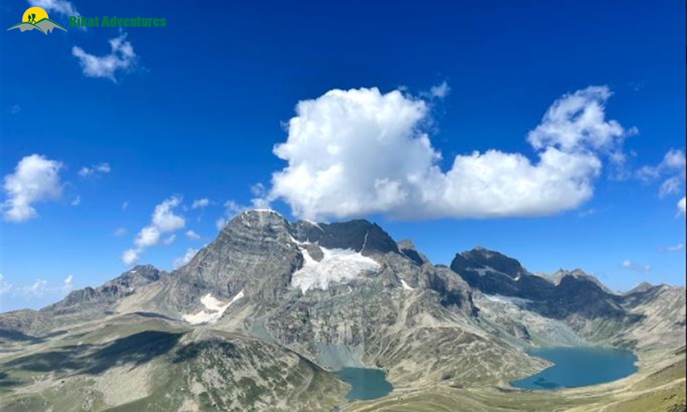
We saw Kashmir's highest mountain - Harmukh. Clouds were playing a game of hide-and-seek, covering its peak. Harmukh was coupled with 2 lakes- Nandkul Lake (where the Harmukh's glacier water would melt eventually) and Gangbal Lake (on the right side, we would go there next day). There was another lake on the very left of Harkukh but it was situated way left to Harmukh . We spotted that lake as well but no as clearly as Nandkul & Gangbal.
We could clearly see that It would require us to finish a very long & steep descent from the top of the Jas pass to reach to the campsite. After nearly 2h+ of trekking, we decided to take a break for lunch and played games afterwards.
Eventually at 2PM we started moving towards campsite & on the way, saw Harmukh more clearly. Some people spent more time for photography etc and stayed back but we started descending & reached at campsite around 3:40 PM. After reaching the campsite, we went to explore the Nandkul lake.
This concluded Day5.
Day 6 (Rest Day)
======================================
Nandkul Lake via Gangbal Lake to Nandkul Lake
Altitude: 11500 ft
Trek Distance: 1km, Time: 1h
This was the best morning so far. No need to be careful of 5,6,7 or 6,7,8 timings as it was a rest day. I went for a monring walk where water stream was present and decided to wash the face . Finally after 7 days(Kidding).
We got informed about the recent curfew imposed in Srinagar with no idea when it would be lifted up. We got scared to find ourselves in the situation of getting stuck in the mountains. Local tour guides assured us that the airports were generally open in curfew situations in Srinagar in the past so no need to worry.
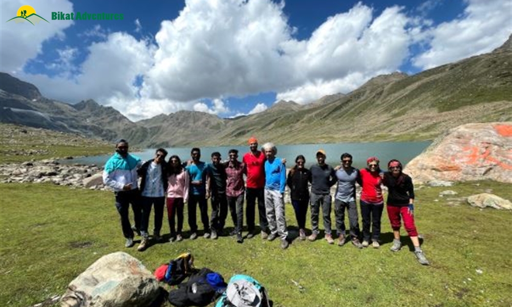
We had breakfast and we trekked for 30m to reach Gangbal Lake around 10:00AM.
We relished time on Gangbal Lake as we were the only group there that day, Water was so clear near the banks that pebbles were clearly visible.We climbed a rock, posed on it and captured memories. Some spent time by going inside the bank of lake and chill.
We then moved to have lunch at campsite and I decided resting in tents afterwards. Some went to spent time at Nandkul Lake. Evening, we had tea and then during dinner we shared our feedback to team Bikat on our overall experiences. There was a surprise birthday cake made by the cooking staff for 2 trekkers. Eventually the whole experience became a lifetime event to remember.
Day 7
======================================
Nandkul Lake to Naranaag
Altitude: 11500 ft to 7450ft
Trek Distance: 16.7 km, Time: 06h50m
We had breakfast, packed our bags and done Jakuza workout before kicking off the last day. A mighty descend awaited us. I was told there are 150+ downhill zig-zags before we reach Naranaag. So I decided to use knee cap for the 1st time in KGL trek.
Start of the day was smooth that involved walking on the meadows. After 3h of trekking, we could finally see the alpines. Kept of descending and we reached the maggie point where some people received mobile signals. We called at our home to give them the updated that we were safe and headed to the city areas.
Then began the most tiring, challenging part of steep descend. We kept of descending but reaching to Naranaag seemed a never ending task. Eventually at 2:25PM we reached Naaranag and waited for all trekkers to arrive. We all were emotional post this as the toughest part which involves saying goodbye was onset. With the promises like "Pics share kar dena/ stay in touch/Next trek saath me karenge etc" we boarded our taxi and left for Srinagar at 4:00 PM :(
This video was created by Mr. Paaras Patel.


")


